


Reprocessing Daily QuikSCAT Surface Wind Fields
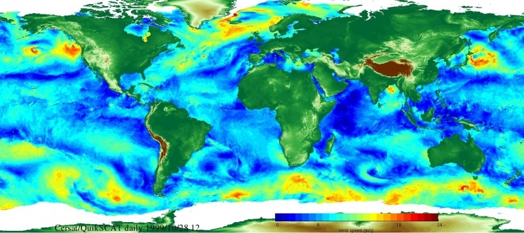
Gridded daily wind vector and wind stress fields, estimated over global ocean from QuikSCAT scatterometer (referred as DQSCAT) data, have been updated. Their spatial resolution is 0.25° in longitude and in latitude. They are produced from the new QuikSCAT wind retrievals indicated as QuikSCAT V3 (https://podaac.jpl.nasa.gov/dataset/QSCAT_LEVEL_2B_OWV_COMP_12). Wind retrievals are provided over QuikSCAT swath at Wind Vector Cell (WVC) of 12.5km spatial resolution. The new scatterometer product is assumed improving wind speed performance in rain and at high wind conditions.
The calculation of daily gridded wind fields from scatterometer wind observations is performed using same objective method used for the estimation of daily ASCAT wind fields (DASCAT) (Bentamy et al, 2011). The resulting wind field accuracy is investigated trough the comparisons with daily-averaged winds from moored buoys. The overall statistics indicate that the daily scatterometer wind fields compare well to daily-averaged buoy data. The rms differences do not exceed 2m/s and 20° for wind speed and direction, respectively. Despite of difference in buoy and scatterometer sampling schemes used for the estimation of daily winds, correlation values attest that satellite daily winds reproduce fairly well in-situ estimates.
The daily wind fields are calculated for the full QuikSCAT V3 period: October 1999 – November 2009. Data are available at IFREMER (ftp://ftp.ifremer.fr/ifremer/cersat/products/gridded/mwf-quikscat/data/daily) and freely distributed. The data files are in NetCDF format supported by several scientific softwares.
Contact : Abderrahim.Bentamy@ifremer.fr and Denis.croize-fillon@ifremer.fr