Nausicaa: an advanced tool for the monitoring of coastal areas
NAUSICAA is an interactive image browser than can be accessed with any recent web navigator supporting Java. It displays daily mosaics of satellite, model or in situ data over predefined geographical areas. These data may consist of images or vectorial shapes (marks, vectors, contour lines) and can be viewed thanks to enhanced interactive tools (zoom, display and extraction of numerical valuesn contrast adjustment, layer overlapping,...). Nausicaa aims at providing a support to monitoring and understanding the bio-geochemical exchanges in coastal areas (algae blooms, etc...).
A European framework: GMES and MarCoast
The GMES (Global Monitoring for Environment and Security) framework is a European initiative to provide the data and facilities required to define the short-term and long-term European environmental strategy. Marcoast, funded by ESA, is one of the first GMES services adressing oil spill monitoring and water quality assessment in coastal areas. Ifremer is a leading parter in this framework and Nausicaa is a contribution to this ambition.
An integrated access to the data for regional and national concerns
One of the main challenges in developing the Nausicaa browsers was to integrate as much as possible, satellite-derived products and measurement at sea (in situ) in order to benefit on the potential of existing networks operating at regional, national or european scale, and related, more or less, to the GMES issues. We can mention amongst those projects, networks or satellite facilities, MEDSPIRATION, GHRSST, CORIOLIS, the SAF (Satellite Application Facility) Ocean and Sea Ice of EUMETSAT/MeteoFrance, the monitoring networks SmartBuoy (CEFAS), REPHY (Ifremer), SOMLIT (CNRS/INSU) for the chlorophyll and the phytoplankton biomass, locally refined in regional network as the RHLN (Réseau Hydrologique du Littoral Normand), SRN (Suivi Régional des Nutriments), ? It is an impossible task to mention all of them but we have to be aware that their contribution to the Nausicaa data base are essential to the success of the Nausicaa/MarCoast project
An extensive database
The main data displayed in Nausicaa browsers have been selected in order :
- to present a comprehensive remote sensing data set over the continental shelf of regional areas processed through locally calibrated algorithms.
- to provide inputs for running biogeochemical models (surface solar irradiance winds, river outflow) and satellite data for assimilation.
They include :
- for satellite : sea surface temperature (climatology, daily images, and weekly anomalies), chlorophyll, mineral suspended particulate matter, wind, solar irradiance.
- for in situ : sea temperature (surface and vertical profiles), chlorophyll, suspended matter, turbidity.
Many other data (sea roughness from SAR, outputs of hydrological models, ?) may complete these datasets depending on the regional area.
Several covered areas
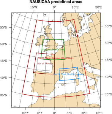
Several browsers are available, focusing on different geographical areas, depending on our users interest or the projects in which Ifremer is involved. The available datasets and their respective historical depth may vary for each browser. New browsers will be added in the future.
- North-West Europe (MarCoast project area)
- Bay of Biscay
- Channel/North Sea
- Gulf of Lion and Corsica
Interesting typical or exceptional situations are highlighted through the following examples :
- Effect of storms on the suspended matter concentration in the Bay of Biscay
- A late winter bloom observed in March 2000
- The May 2001 bloom : the largest bloom observed over the 4 year period of SeaWiFS observation
- Upwelling filaments north of the Iberian peninsula in September 2000
Bay of Biscay
Certainly the most complete. It has an archive in sea temperature going back to June 2001, SeaWiFS data since the beginning of 1998, almost daily since April 2002
Channel and North Sea (Roses)
The browser named ROSES (from the name of one of the MarCoast precursor projects) cover the Channel and the Southern North-Sea. Its archive is similar to that of the Bay of Biscay browser (excepted the SAR data)
Gulf of Lion and Corsica
The archive of the Mediterranean Sea browser is not as complete as those of the Biscay and ROSES browsers but it shows outputs of the Ifremer hydrological model (currents, SST, salinity) and may be considered as pioneer for the other browsers.
North-West Europe (MarCoast)
Last but not least. There is no SeaWiFS archive in this server which covers a wide area and has been designed to support present and future European projects.


