


Monitoring sea ice using scatterometers of the ERS satellites
|
|
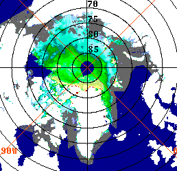
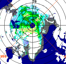
Images of the backscatter coefficient over the Arctic region, observed at 40° incidence angle during the third weeks of October 1995 (ERS-1, left) and October 1996 (ERS-2, right). In navy blue: unprocessed areas; in grey: open water. The highest values of the backscatter coefficient are observed for multi-year ice (ice having survived at least one summer) which appears in green or yellow on the images. The image pair shows how different the situations can be from year to year. In October 1996, new and multi-year ice cover the coastal zones of Siberia where large surfaces of open water were apparent on the 1995 image.
Sea ice extent over polar oceans is a major critical parameter for understanding and forecasting oceanic circulation and earth climate changes. No satisfactory conventional observing system is available and sea ice is difficult to observe using satellite optical sensors because of the low level of illumination in polar regions and because of frequent cloud cover.
Microwave instruments and in particular satellite-borne radars, such as scatterometers, are of major interest, first because of their large temporal and spatial coverage and second because of their all-weather measurement capability. Such instruments are flown on the European Remote-Sensing Satellites of the European Space Agency. The development of specific data analysis methods for these radars led not only to the estimation of global ocean surface wind fields (the primary objective for this sensor), but also to the detection of sea ice and to the estimation of its extent and age
A routine processing is now used to produce fields of sea ice age and extent, on a global coverage and on weekly and monthly basis. Both wind and sea ice data are available, with data extraction software and display capabilities, on CD-ROMS.
The European Remote-Sensing Satellites ERS-1 and ERS-2, launched by the European Space Agency respectively on July 17, 1991 and on April 21, 1995, each carry a C-band scatterometers, primarily dedicated to sea surface wind field measurements. The Active Microwave Instrument of ERS in wind mode (or scatterometer) is a three-antenna radar at 5.3 GHz. The three beams sample the sea surface at azimuth angles of 45°, 90° and 135° with respect to the satellite flight direction. The radar illuminates a 500 km wide swath at incidence angles ranging from 18° to 57° . Radar measurements are binned over 50 km wide overlapping cells, the centres of the cells being separated by 25 km. The sea surface backscatter coefficients ( sigma0), measured by the three beams, are computed in each 25 km x 25 km grid cell.
Over polar oceans, values of sigma0 measurements depend on the dielectric properties of the observed materials: sea water, first-year ice and multi-year ice, on their relative concentrations and on surface topography. As sea ice ages, its dielectric properties, linked to volume and surface scattering, as well as its surface roughness are modified. Sea ice characteristics are derived from sigma0 levels at prescribed incidence angles (40° and 50°), and from sigma0 variation with incidence angle at low incidence (28°). An ice mask is also constructed using the normalized distance from the measured backscatter triplets to the wind-over-water backscatter model, in order to eliminate the ice contaminated areas for wind vector retrieval. In summer, surface melting of sea ice changes the sigma0 signature and renders more difficult data interpretation.
The main applications of this type of data need regularly space and time gridded sea ice fields. Because of the limited size of the measurement swath and of the quasi-polar orbit, the data measurements are discrete in both time and space. Scatterometer data are thus asynoptic. Methods have been developed to provide regularly spaced fields over ocean basins. An objective analysis technique is used for interpolation. The ice mask and the three parameters characterizing ice age are produced weekly, with a 50 km spatial resolution. All of these data are available on CD-ROM, presently over the 5 year period from 1991 to 1996. Detailed information can be obtained from CERSAT web site or by e-mail fpaf@ifremer.fr.
Since August 1996, a new sensor, the NASA SCATterometer (NSCAT) has been flying on the Japanese satellite ADvanced Earth Observation System (ADEOS). It is a Ku band scatterometer and it will provide similar information but with better spatial and temporal resolution because of its double swath and its 25 km resolution. In addition ESA and EUMETSAT are jointly planning a series of operational double-swath C-band scatterometers for flight beyond the year 2003 on the Metop satellite series.