


ERS-1
 The ERS Program (European Remote Sensing satellite system) of the European Space Agency is one of the most essential part of an important european earth observation program concerning: meteorology, climatology, oceanography, land resource management...
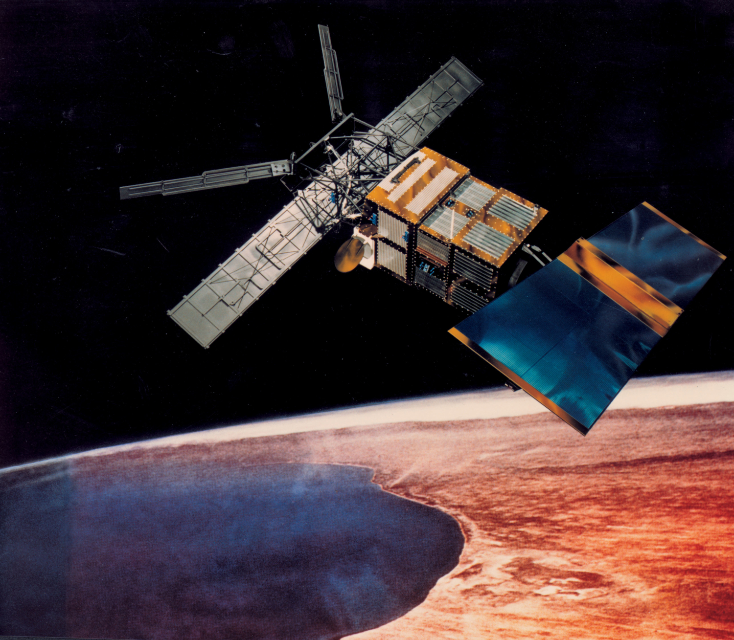
ERS-1 was the first of two twin earth observing satellites launched by ESA respectively in July 1991 and April 1995. It included, in addition to other instruments, several sensors relevant for oceanography such as the RA radar altimeter (measurement of the sea surface topography, the wave height,...), the AMI-Wind scatterometer (measurement of the surface wind speed and direction over the ocean), the SAR (measurement of wave spectra) and the MW micro-wave sounder (brightness temperature, atmospheric vapour content,...).
The ERS-1 mission ended on 10th March 2000 (its sensors had been on stand-by since 1995). Nevertheless, thanks to the length of the ERS mission (more than 15 years), an impressive continuous and homogeneous series of sea surface parameters could be collected all along the mission.
The plateform is based on an existing design developed for the French SPOT satellite. Payload electronics are accomodated in a box-shaped housing on the plateform, antennas are fitted to a bearing structure.
 ERS-1, the first satellite of this programme was launched in July 1991.
The ERS-1 mission is essentially turned to the multi-year monitoring of oceans, ice zones and coastal regions. Its platform carries active instruments which measure physical parameters such as significant wave heights, wind speeds and directions, or sea surface temperature.
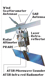
ERS-1 carries instrumentation consisting of a core set of active microwave sensors supported by additional, complementary instruments :
- An Active Microwave Instrument (AMI) combining the functions of a Synthetic Aperture Radar (SAR in image and wave mode) and a Wind Scatterometer. The SAR operates in image mode for the acquisition of wide-swath, all weather images over the oceans, polar regions, coastal zones and land. In wave mode, the SAR produces imagettes (about 5 km x 5 km) at regular intervals for the derivation of the length and direction of ocean waves. The Wind scatterometer uses three antennae for the measurement of sea surface wind speed and direction.
- A Radar Altimeter (RA) providing accurate measurements of sea surface elevation, significant wave heights, sea-surface wind speeds and various ice parameters.
- An Along-Track Scanning Radiometer (ATSR) and Microwave Sounder (MW) combining infrared and microwave sensors for the measurement of sea-surface temperature, cloud top temperature and cloud cover and atmospheric water vapour.
- A Precise Range and Range Rate Equipement (PRARE) for the accurate determination of satellite position and orbit characteristics, and for geodetic 'fixing' of ground stations.
- A Laser Retro-Reflector (LRR) enabling measurement of satellite position and orbit using laser ranging stations on the ground.
In short, the ERS-1 platform contains complementary instruments allowing observations of Earth with high accuracy, in all weathers, night and day.
Property | Value |
Total mass | 2400 kg |
Overall height | 11,8 m |
Solar generator | 11,7 x 2,4 m |
SAR antenna | 10,0 x 1,0 m |
Scatterometer antennas | |
| 3,6 x 0,25 m |
| 2,3 x 0,35 m |
Radar Altimeter antenna | 1,2 m in diameter |
Additional Info
- Mission: ERS-1
- Agency: ESA
- Orbit: polar
- Altitude: 800 km
- Launch date: Wednesday, 17 July 1991
- Status: terminated
- Mission end: Friday, 10 March 2000